


Driving Routes
Discovery Trail: Glenbrook

- Length
- 47 kms (from Glenbrook and return)
- Driving Time
- 3 hrs (from Glenbrook and return)
- Road Conditions
- Narrow sealed and unsealed roads, National park entry fees apply
- Start and Finish
- Glenbrook
- Snapshot
- Glenbrook Creek, Dharug Aboriginal art at Red Hands Cave and relaxed kangaroos at Euroka Camping and Picnic Area.
- Highlights
- Explores the sandstone 'Blue Labyrinth' beyond Glenbrook Creek gorge on a multi-pronged drive. Lookouts, picnic areas, walking tracks and creek waterholes.
- Alerts!
- Narrow, winding roads. Some unfenced cliff-tops.
From the village of Glenbrook, follow Glen Road eastward along the railway line, into Bruce Road, across the railway line and to the Glenbrook entrance to Blue Mountains National Park. An entry fee applies, and the gate is locked at 7pm (during daylight saving) or 6pm (all other times), and re-opens at 8.30am.
The sealed road descends steeply to cross Glenbrook Creek. On the way down, a parking area and short walking track to Blue Pool is passed on the right. The pool featured in the Australian movie Sirens. It has good swimming and is well worth a stopover (perhaps on the way back).
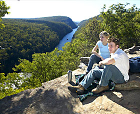
The road (the Oaks Fire Trail) crosses a causeway on the creek (which may be uncrossable after rain) and climbs up the other side of the gorge onto the plateau, past the walking track to Euroka and another parking area. About 1.5km from the creek, turn left into the Euroka Road, then after another 0.6km left again into the unsealed Mount Portal Road. A steep pinch leads to the carpark for Tunnel View Lookout, where a short walk leads to a dramatic clifftop lookout above Glenbrook Gorge. Part of the western railway line can be seen across the gorge.
Back at the road, continue on another kilometre or so to Mount Portal Lookout. This fenced viewpoint has wide views across the Nepean River to Penrith and western Sydney. Return the same way and turn left into the sealed Euroka Road and descend into Euroka.
The valley was cleared for farming by early settlers because of its richer volcanic soil - the result of an explosive volcanic vent that burst through the sandstone some 200 million years ago. Today it is a magnificent picnic and camping area, with extensive grasslands, tall Sydney blue gums and numerous relaxed Eastern Grey Kangaroos. Please don't feed or try to pat the kangaroos. Euroka is believed to be a Dharug word for sun, so this sheltered basin is well named and a great place for a picnic lunch. Bookings are required for camping (phone 02 4588 5247).
After a pleasant interlude, follow the sealed road back up the hill to the Oaks Fire Trail and turn left onto the unsealed surface. A small picnic area is passed at The Ironbarks, then after some 5km The Oaks picnic area and a junction. Keep left, then left again, into Nepean Lookout Road. This leads past short walking tracks on the right to Pisgah Rock and Erskine Lookout, then terminates at a carpark. A short stroll to Nepean Lookout will reward with views over Fairlight Gorge, where the ancient Nepean River cut down into the foothills of the Blue Mountains as they were lifted up.
Return the same way to The Oaks, and turn left into Red Hands Cave Road for our final stop. The carpark is some 4.5km from The Oaks. A short downhill track leads to a sandstone overhang, where extensive panels of stencil art are protected by an enclosure. The art is typical of Dharug sites elsewhere, and much art throughout the Sydney sandstone region. Just why the Dharug left their hand stencils and prints on the rock is unknown, but similar signatures are found in many parts of the world and are a poignant reminder of a common humanity across thousands of years.
Return to Glenbrook the way you came, along Red Hands Cave Road and the Oaks Fire Trail. Of course the various points on this tour can be visited in any order.